The History of Englewood Cliffs
The Borough of Englewood Cliffs had two nineteenth century settlements: Undercliff and Coytesville. Each of these locations had a unique historical identity of its own. Undercliff, which was settled as early as 1825, was a collection of small fishing villages that dotted the Hudson River shoreline before the coming of the Palisades Interstate Park in 1900. Coytesville, the majority of which lies in the Borough of Fort Lee, is located at the southern border of Englewood Cliffs. Coytesville was divided into lots in 1851.
Political Genealogy
The present Borough of Englewood Cliffs was incorporated in 1895. Earlier, the area was part of the now defunct Townships of Englewood and Palisades, which had been formed in 1872 from part of Hackensack Township.
Early History to 1900
.jpg)
Undercliff School
First school in Englewood Cliffs |
.jpg)
Captain Charles von Wagoner in front of
his Undercliff home |
The Undercliff colony, which consisted of a number of small fishing villages that stretched from Edgewater to Alpine, was settled as early as 1825 by people of predominantly Dutch ancestry. The Villages of Englewood Dock, Pickletown, Bloomer's Beach, and Fisherman's Village occupied the waterfront within the present Englewood Cliffs. The Village of Englewood Dock, which was located at the foot the mountain road (the old Dyckman Street Ferry Road) that winds its way down from Palisade Avenue to the River, was the port through which farmers from northern New Jersey shipped their produce to New York markets. By the mid-nineteenth century, rock quarrying became a lucrative operation, and after the Civil war, the cliffs were threatened with annihilation by blasting. This, in part, brought about the creation of the Palisades Interstate Park to ensure the survival of the Palisades. With the park however, came the abandonment of the Undercliff settlements. Traces of these fishing hamlets, such as the Undercliff cemetery, remain as potential archeological sites.
.jpg)
Englewood Cliffs' first post office
was in Coytesville |
The Village of Coytesville, the northernmost part of which presently lies in Englewood Cliffs, was an early speculative subdivision of lots laid out by the Englishman Joseph Coyte in 1851. In the days before shopping malls and supermarkets, Coytesville provided all the services the community needed: a post office, a grocery store, a vegetable store, two delis, a butcher shop, a drug store, a bakery, a luncheonette, a soda fountain, a handicraft store, a hardware store, four saloons, three churches, and a cemetery. Trolley service provided by the Palisades Road and Turnpike Company brought passengers from points south. Several of the early vernacular homes, many of which have been substantially altered, remain interspersed among newer buildings. Woodland Cemetery, where many of the early homeowners are buried, is located in Englewood Cliffs at the end of Hickory Street.
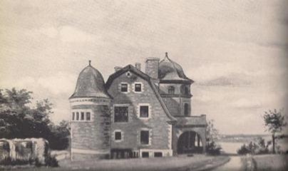
William Dana's 1860 Greycliff Estate |
.jpg)
Palisade Mountain House |
The first of several large estates that were constructed atop the Palisades in the second half of the nineteenth century was that of William B. Dana, the foster father of Englewood Cliffs' first mayor, William O. Allison. Built in 1861, Greycliff stood at the cliff's edge near Demarest Street. No estates have survived the creation of the Palisades Interstate Park, although some traces of ruins lie amid the woods and the undergrowth near the edge of the cliffs.
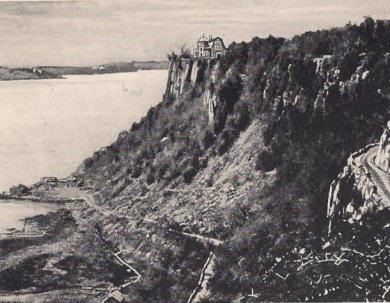
In the second half of the nineteenth century, the Hudson River waterfront and the Palisades Ridge became a popular country resort for wealthy New Yorkers. The fresh air and rustic settings of northeastern Bergen County offered a healthful reprieve from the heat and the dust of the crowded city. One such resort was the Palisade Mountain House, which stood at the cliff's edge on the site presently occupied by Saint Peters' College in Englewood Cliffs. The 4-story brick and stone hotel had porticoes on three sides with towers and a mansard roof in the best Victorian style of architecture. A Hudson River dock was built that allowed two steamships per day to transport guests from lower Manhattan. The resort was short lived; in 1884 it was destroyed by fire and never rebuilt. The dock, however, lived on to become the terminal of the Dyckman Street Ferry that connected Englewood Cliffs with Manhattan until 1942.
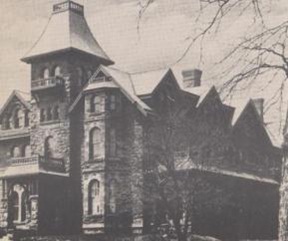
Soon after the destruction of the Palisade Mountain House, William O. Allison constructed his estate on the site of the ruined resort. The mansion and its buildings were designed by the New York architectural firm of J.E. Cady and Company, who also designed New York's old Metropolitan Opera House (demolished) and the earliest wings of the American Museum of Natural History. Cady (b.1837), who practiced in New York City from 1864 until his death in 1919, owned a summer estate in Alpine. He designed several other buildings in Bergen County, including the Alpine United Methodist Community Church and the Demarest Train Station. Allison's picturesque Colonial Revival Mansion burned in 1903 (the foundation still exists), but the coachman's quarters with its diabase bearing walls, brownstone trim, and gambrel roof remains as the best extant example of picturesque late nineteenth century architecture in Englewood Cliffs. In addition, it is the only building here to have survived from the days of the great cliff top estates.
The Allison estate atop the palisades |
Allison mansion |
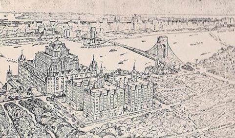
In 1886, two years after Allison completed his mansion, the Sisters of Saint Joseph of Peace purchased 5 1/2 acres of land to the south of Allison Estate. Here they built a summer retreat for young women, which is presently known as the Villa Lourdes, a home for aged sisters. In 1905, the sisters increased the size of their property to 12 1/2 acres through the purchase of the abandoned Allison Estate. Two years later they constructed the Saint Joseph's Orphanage and School for Boys at the south end of their land. Although the orphanage burned in 1953, the austere school building, which consists of local Palisades diabase rock, is presently occupied by Saint Peter's College. In 1938, the Sisters built the Saint Michael's Novitiate. This large Romanesque Revival edifice, a visual landmark along the Hudson River, was designed by architect Robert Reilly of New York City. Saint Michael's is characterized by its yellow brick bearing walls, arcaded window bays, and square central tower with an octagonal upper stage that is topped by a red tile polygonal roof. This monumental building is visually prominent from the Palisades Interstate Parkway and it dominates the New Jersey skyline north of the George Washington Bridge as viewed from New York.
The Early Borough
The first Mayor, William O. Allison, is to be credited with the founding of the Borough, for he was the prime supporter of our incorporation in 1895. At this time approximately 200 people resided within Englewood Cliffs.
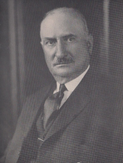
William O. Allison
first mayor of Englewood Cliffs |
In 1900, the Palisades Interstate Park was created and the cliffs and the waterfront were purchased for the park. As a consequence, the Undercliff settlements were vacated, which cost the borough a good deal of its tax base. An even greater blow to the municipal coffer was brought about by the additional and unexpected surrender of the large cliffside estates to the tax exempt Palisades Interstate Park. After making an agreement with the estate owners to limit the park to the area between the edge of the cliff and the Hudson River, the park commission decided suddenly to include the land on top of the cliffs, as well.
During the 1910's, Fort Lee, Englewood Cliffs' southern neighbor, became the first capital of the American picture industry. The rural character of Fort Lee and its convenience to Manhattan's Broadway satisfied the need for an open area near the city where filming could proceed undisturbed. New York based movie companies first began cranking out footage in Fort Lee in 1907, but the first permanent studio in the area was built in Englewood Cliffs in 1909. The utilitarian frame building on 5th Street in Englewood Cliffs that housed the Champion Film Studio, a precursor of Universal Studios, is still extant and is a significant remnant of Bergen County's past importance in the movie industry. Although some motion pictures were filmed within Englewood Cliffs, restrictive municipal ordinances precluded the growth of the movie industry within the borough. These laws dis-allowed any filming without permits and prohibited the use of firearms and explosives of any kind during the making of films. New Jersey's motion picture boom was short lived. By the early 1920's, the industry departed for the year-round warmth of southern California, which offered lower taxes, more varied scenery, and fewer constraints, in addition to better weather.
Simultaneously with the rise of filmmaking came the first wave of automotive ownership, both of which brought about a small boom in residential and commercial development within Englewood Cliffs. Between 1900 and 1920, the borough's population increased by 150%, from 218 to 534, and Englewood Cliffs' rural environment began to change. Sylvan Avenue, which at the turn of the century was a well-kept country road with gentle curves, became known as "the strip" during the teens because of the several bars and roadhouses that were opened to serve a new and transient clientele.
Proposed Paterno development at Sylvan and
Palisade Avenue 1926 |
By the 1920's, with the rapid growth of automobile usage, the prospect of a Hudson River crossing to Bergen County led to real estate speculation in Englewood Cliffs. In 1925, the first applications for builder's houses on 50' x 100' lots were approved. Two years later, construction of the George Washington Bridge was underway and speculative activity shifted into high gear. Dr. Robert Paterno, a New York real estate player, planned a $5 million apartment house complex at Sylvan and Palisade Avenue in Englewood Cliffs. Also in 1925, 47 building lots on Sylvan Avenue, two blocks south of Palisade Avenue were priced at $4600 each and 129 lots near Summit and Palisade Avenue cost $6100 apiece. This period of intense real estate speculation was cut short by the Crash of 1929 and the ensuing Depression. As a consequence, Paterno's mammoth apartment house city never materialized, but the borough's population had nevertheless jumped to 809 by 1930. The additional residents produced a need for a new school, which was built on Bayview Avenue between 1919 and 1922.
Along with the dedication of the George Washington Bridge in 1931 came yet another upsurge in commercial development in Englewood Cliffs. Road stands, gas stations and liquor stores became pervasive landscape features. In 1932, Englewood Cliffs adopted its first zoning ordinance in an attempt to regulate the spread of commercial blight. By 1934, the borough had enacted a building code.
Allison Park was opened in 1934 on the 2.79 acres of land that was willed to the borough by the former first mayor Allison for the express purpose of creating a public park. This picturesque park, which affords a dramatic view of the Hudson River, is a fine example of the picturesque landscape architecture of the 1930's.
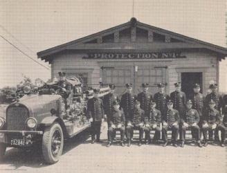
Fire department on Bayview Avenue 1926 |
The Post World War II Borough
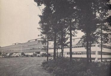
Prentice Hall was the first of the corporate
campuses that defined our modern business zone. |
Englewood Cliffs matured into the modern community it is today following the Second World War. The Borough was on the threshold of a 20 year interval during which the number of residents surged from 966 to 5938. The Palisades Interstate Parkway, which became the second major highway to traverse Englewood Cliffs, was under construction by 1947. Later that year, the vast Allison lands, some 700 acres, were placed on the market. By 1950 post war growth pressures burdened the still semi-rural community. New York City was expanding into the suburbs, and developers pressed for factories and apartment buildings.
Simultaneously, a modern trend in development arrived in Englewood Cliffs, the large campus-like office complex. Corporations were attracted to suburban locations like Englewood Cliffs by lower taxes, additional space, and modern facilities. The first of these expanding concerns to locate in Englewood Cliffs was Prentice-Hall, Inc., which constructed a warehouse and office building on Sylvan Avenue in 1953. The value of this type of development was immediately recognized. The office sites were clean, beautifully landscaped, and they contributed significantly to the Borough’s tax base. As a result our zoning code was redrawn. The Zoning Code of 1954 eliminated factories and apartment buildings and divided the Borough into zones of single family residences separated by buffer zones from office buildings along Sylvan Avenue. Thanks to these changes, Englewood Cliffs enjoys some of the lowest property tax rates in New Jersey.
By the end of the 20th Century Englewood Cliffs was fully developed, with almost no land available for further building. Because of our high land values the Borough has seen significant re-development taking place. Older homes and businesses are being removed and replaced by newer ones. The character of the Borough, however, remains the same.
Credits
Bergen County Historic Sites Advisory Board, 1981-1982
The Story of Englewood Cliffs, James J. Greco, © 1964 by Tercentary Committee, Englewood Cliffs, NJ
The History of Englewood Cliffs: 1964-1994, Caye Jehn and Russ Jehn, © 1995 by Englewood Cliffs Centennial Committee, Inc., Englewood Cliffs, NJ